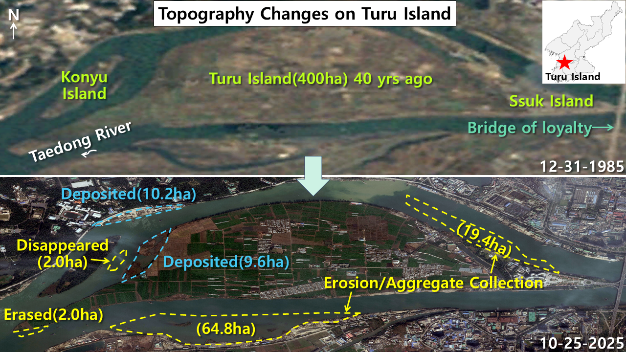
Daily NK reported that uninhabited islands in Pyongyang’s Taedong River have recently begun disappearing due to indiscriminate aggregate extraction. Satellite image analysis of the Turu Island area in Pyongyang’s Rangrang district has revealed changes large and small in the terrain over the last 40 years. Silting has created 20 hectares of new land, but flooding and aggregate extraction have led to the disappearance of 88 hectares. In the southwest part of Turu Island, accelerating work to dismantle uninhabited Tudan Island had reduced the island to about one-third of its original size as of Oct. 25. Tudan Island will likely disappear completely beneath the Taedong River’s waves by the end of the year.
Flooding and silting reshape landscape

Transformations large and small have occurred on Turu Island and its environs over the last 40 years. A comparison of satellite images taken Oct. 25 with Google Earth images from late 1985 shows dramatic changes. To the left of Turu Island, a small uninhabited island 2 hectares in area between Turu Island and Konyu Island has disappeared. The very far left end of Turu Island, about 2 hectares, has been shaved off, sharpening the topography — flooding appears to have carved it off. On the right side of Turu Island, 19.4 hectares of land appear to have disappeared over the last 40 years, likely the result of flooding on the Taedong River or aggregate extraction. To the south of the island, a broad swath of 64.8 hectares has been carved off, which likewise appears to be the result of flooding or aggregate extraction.
Turu Island — also known as Turo Island — is an alluvial island in the middle of the Taedong River in Pyongyang’s Rangrang district. Alluvial islands are formed in rivers by the accumulation of sand and gravel. Typical examples are Seoul’s Yeouido and Busan’s Eulsukdo. Alluvial islands have significant ecological and geographic value because they form naturally. Since they are located in the middle of flowing rivers, they are often used as wetlands or migratory bird habitats. Thanks to their fertile soil and favorable drainage, they are also important sites for crop production, including vegetables. Turu Island used to be an alluvial island covered in wetlands and vegetation, but it has since been converted into farmland — greenhouses cover much of the island, which is now one of Pyongyang’s major sources of vegetables. Turu Island is about 400 hectares in area. To its right is Ssuk Island, which got its name because mugwort grows in abundance there. It was also the site of the 1948 meeting between North Korea’s Kim Il Sung and South Korean independence fighter and politician Kim Ku.
Dismantling accelerates

Efforts to dismantle Tudan Island — also known as Taekki Island, located to the southwest of Turu Island — are accelerating, as is aggregate mining. Tudan Island was originally a long, oval island of 3.6 hectares. Satellite images show that one-third of the island had been chopped away by mid-June, and less than half remained by mid-September — the island was fragmented, as if insects had eaten it away. In satellite images taken in late October, two-thirds of it had disappeared, with only about 1.3 hectares remaining. The island is now only 36% of its original size, barely more than a third. Dredging boats were lined up along the island’s upper and lower shores, with dismantling activities accelerating. Tudan Island will likely disappear completely beneath the Taedong River’s waves by the end of the year.
The dismantling of Tudan Island is believed to be a rushed process driven by aggregate extraction to secure basic building materials for housing and road construction in Pyongyang, but it might also be linked to strategic businesses that export to China. Daily NK reported that with mineral exports like coal and iron ore having been blocked by economic sanctions for years, North Korea secretly signed an export contract with China. Exports of North Korean sand and gravel are also prohibited under U.N. Security Council sanctions. The possibility that, in addition to securing construction materials, the dismantling of Tudan Island is also linked to regime efforts to secure foreign currency cannot be excluded. North Korea’s exports of aggregate for foreign currency would not only cause the international community headaches as violations of U.N. sanctions but also warrant attention as an environmental risk, as they transform river topography and damage natural wetland ecosystems.